Indigenous Languages
Details
Permalink to Details- Added to the Catalog
- Available for
- SOS
- Explorer
- Categories
- People: Demographics, History
- Keywords
- Indigenous
- Land Acknowledgement
- Native
- Territories
Description
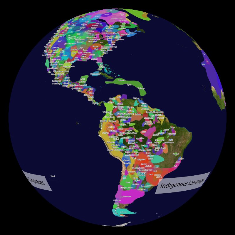
Permalink to DescriptionNative-Land.ca has built a map of Indigenous peoples’ lands, territories, and languages, which has become a widely-used source for land acknowledgments. This particular dataset displays information about Indigenous Languages. NOAA’s Science On a Sphere (SOS) team used the information provided to create a dataset for SOS that can be used as a tool to start collective dialogues and raise awareness about these topics. It can also be used as a starting canvas to build additional Indigenous-related content. Even though a complete global dataset is lacking, we want to provide an introductory global context to Native land and language history. Challenges and struggles of Indigenous Nations are a global problem, and nuances around this topic can vary greatly from country to country.
Indigenous peoples have gathered an immense amount of diverse and intertwined knowledge over centuries of being part of their homelands' ecosystems — for many Indigenous peoples, there is not a separation between people and the environment. This knowledge continues to be built upon today and is reflective in their continued stewardship, conservation, and land management approaches. Colonialism has dramatically changed these land-nations' relationships with the reduction of indigenous lands, forced relocations, etc. One of the results of colonization was the displacement of many Indigenous peoples from their traditional lands and the loss of some Indigenous languages. This map is an attempt to provide a visual representation of Indigenous languages around the globe before their interaction with European settlers.
Land acknowledgments are one way to acknowledge Indigenous land rights. As mentioned in the Native-land.ca website: “Territory acknowledgement is a way that people insert an awareness of Indigenous presence and land rights in everyday life”. However, land acknowledgments shouldn’t just be an empty gesture “... these acknowledgements can easily be a token gesture rather than a meaningful practice. All settlers, including recent arrivants, have a responsibility to consider what it means to acknowledge the history and legacy of colonialism.”
It’s also important to clarify that this map is not intended to be an official, scientific, or legal representation of Indigenous borders, nations, or history. This is a community-led project, and it continues to require refinement from within each community. We also suggest using the lack of data and the characteristics of it, such as its global distribution, not as a limitation, but as a discussion starter:
- Why are there no data in those locations?
- Why are there so many overlays in the Americas, compared to fewer overlays in Australia?
- Why do we have every mile of Earth mapped from space, but we can’t piece together the history of Native nations around the globe?
For example, the lack of information about other continents, such as Africa, is explained by Native-Land.ca as follows: “...what does it even mean when we’re talking about “Africa”? It’s a term often used in Western countries as though it was a single thing — “Africa” — as though it was one country, one history. But obviously this isn’t even close to the case. It’s an enormous continent, with an enormous history of human habitation and extraordinarily complex relations between peoples, traditions, ethnicities and history. There are many countries, often tied up with colonial history, with complex borders and inter-relations.”
Addressing Indigenous history requires much more than a land acknowledgment. We need to be conscious that this topic is much more than just an ice-breaker, but it is a reflection on the history of the interactions between settler-colonial society and Indigenous communities, as well as their ongoing and current struggles. We hope this dataset aids in discussions of Indigenous sovereignty and facilitates learning from the incredibly large pool of community knowledge that Indigenous peoples possess.
To learn more about these topics please visit:
Dataset Information and Features:
Permalink to Dataset Information and Features:The dataset contains individual layers created based on json files available here. They were processed using ArcGIS Pro (for a free alternative use QGis) and exported in the appropriate SOS input format (png file format with a 2:1 aspect ratio using an equatorial cylindrical projection).
The dataset is composed of the following individual layers:
- Native languages
- Native languages names
Notable Features
Permalink to Notable Features- This map is not intended to be an official, scientific, or legal representation of Indigenous borders, nations, or history
- A complete global dataset is not available; this incomplete dataset is meant to provide an introductory global context to Native land and language history
- The labels for the languages are a layer that can be turned off