Buoys: Argo (by Country)
Details
Permalink to Details- Added to the Catalog
- Available for
- SOS
- Categories
- Water: Ocean Monitoring
- Keywords
- Argo
- Buoy
- El Nino
- La Nina
- Measurements
- Nature Of Science
- Oceans
Description
Permalink to DescriptionThe Argo Program supports a global array of about 4,000 robotic profiling floats that measure the temperature and salinity of the ocean. Once deployed into the ocean, Argo floats dive between one and nearly four miles deep, to collect data and drift with the currents. Every 10 days, the floats surface to transmit a “data profile” — a snapshot of ocean information captured by the floats on their way up . Those data are transmitted by satellite to global data centers, where the information collected by the floats is publicly available for free. On average, floats last five years on battery life, collecting ocean information from hard-to-reach parts of the globe, and weather events that are too dangerous for humans to venture to, like hurricanes.
The original Argo array consisted of core floats measuring temperature and salinity in the upper 1.2 miles (2,000 meters) of the ocean. In recent years, scientists and engineers have developed new capabilities and new types of floats that can dive even deeper and take different kinds of measurements. The Argo Program is an international program with participation from close to 30 countries. This partnership allows, for the first time, constant monitoring of the temperature, salinity, and currents of the upper ocean. The Argo Program was developed in 1999 and just celebrated two major milestones: the 25 year anniversary of the Argo Program and the milestone of collecting three million “data profiles” – snapshots of ocean information collected while these robotic floats dive through the water column. Over 25 years, Argo floats have collected four times the amount of ocean information than all other ocean observing tools, like ships and moored buoys, combined.
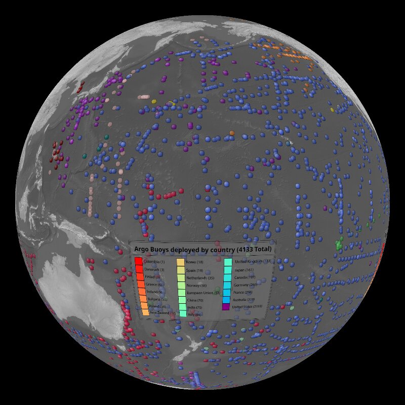
The Argo Program is named after the Greek mythical ship Argo, which was captained by Jason, leader of the Argonauts. Argo was named to emphasize the complementary relationship between Jason satellite products and Argo floats. This visualization shows 4,133 Argo floats operational in March 2025 with the color of the marker reflecting the country responsible for deploying the float. Of the 4,133 Argo floats, 249 of these floats are specialized Biogeochemical Argo floats (BGC floats) and 13 of these floats are specialized Deep Argo floats.
Content Creation Details
Permalink to Content Creation DetailsData was obtained as a CSV file and cleaned using spreadsheet software. Python code was developed to create the frames.
Notable Features
Permalink to Notable Features- All operational floats
- All operational floats colored by country
- Individual country layers
- PIPs showing images and video of the argo floats
Data Source
Permalink to Data SourceWorld Meteorological Organization Intergovernmental Oceanographic Commission (WMO-IOC) Joint Centre for Oceanography and Marine Meteorology in situ Observations Programmes Support - OceanOPS Dashboard