Blue Marble - Seasonal
Details
Permalink to Details- Added to the Catalog
- Available for
- SOS
- Explorer
- Categories
- Land: Blue Marble, Land Cover
- Keywords
- Blue Marble
- Earth
- Land
- Land Cover
- MODIS
- Ocean Cover
- Satellites
Description
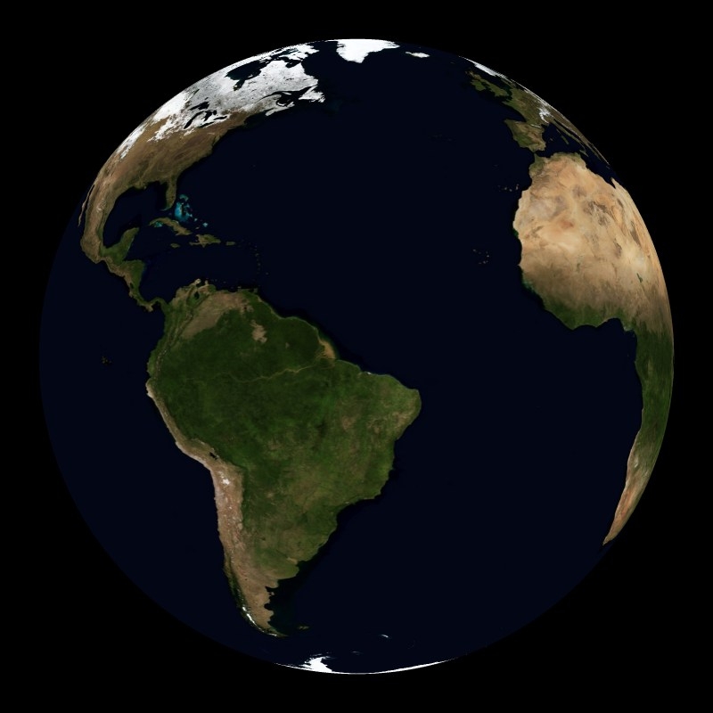
Permalink to DescriptionThe Blue Marble is an incredibly detailed, true-color depiction of the Earth. NASA is responsible for this dataset made from a compilation of satellite images throughout 2001. Most of the information came from NASA's MODIS, the Moderate Resolution Imaging Spectroradiometer, which is attached to the Terra satellite 435 miles above Earth. The background image of the land and oceans was created using data from June through September of 2001. This could not be done in a single day or even a week because on any given day clouds are blocking a significant portion of the surface.
The shading is true color with the oceans shades of blue and the lands varying from green to brown. The brown areas are the sands of the deserts. The shading of the land was done using a dataset compiled by the U.S. Geological Survey's Earth Resources Observation and Science Data Center.
Seasonal Blue Marble without clouds is a monthly composite of the entire year. The monthly evolution allows audiences to see the changing appearance of the Earth due to the season changes. The most dramatic change is the expansion of the snow cover during the winter months and then the depletion of it during the summer months.
Next Generation Science Standards
Permalink to Next Generation Science StandardsCross-cutting Concepts
Permalink to Cross-cutting ConceptsGrades K–2
C3 Scale Proportion and Quantity. Students use relative scales (e.g., bigger and smaller; hotter and colder; faster and slower) to describe objects. They use standard units to measure length.
C4 Systems and System Models. Students understand objects and organisms can be described in terms of their parts; and systems in the natural and designed world have parts that work together.
Grades 3–5
C3 Scale Proportion and Quantity. Students recognize natural objects and observable phenomena exist from the very small to the immensely large. They use standard units to measure and describe physical quantities such as weight, time, temperature, and volume.
C4 Systems and System Models. Students understand that a system is a group of related parts that make up a whole and can carry out functions its individual parts cannot. They can also describe a system in terms of its components and their interactions.
Grades 6–8
C3 Scale Proportion and Quantity. Students observe time, space, and energy phenomena at various scales using models to study systems that are too large or too small. They understand phenomena observed at one scale may not be observable at another scale, and the function of natural and designed systems may change with scale. They use proportional relationships (e.g., speed as the ratio of distance traveled to time taken) to gather information about the magnitude of properties and processes. They represent scientific relationships through the use of algebraic expressions and equations
C4 Systems and System Models. Students can understand that systems may interact with other systems; they may have sub-systems and be a part of larger complex systems. They can use models to represent systems and their interactions—such as inputs, processes and outputs—and energy, matter, and information flows within systems. They can also learn that models are limited in that they only represent certain aspects of the system under study.
Grades 9–12
C3 Scale Proportion and Quantity. Students understand the significance of a phenomenon is dependent on the scale, proportion, and quantity at which it occurs. They recognize patterns observable at one scale may not be observable or exist at other scales, and some systems can only be studied indirectly as they are too small, too large, too fast, or too slow to observe directly. Students use orders of magnitude to understand how a model at one scale relates to a model at another scale. They use algebraic thinking to examine scientific data and predict the effect of a change in one variable on another (e.g., linear growth vs. exponential growth).
C4 Systems and System Models. Students can investigate or analyze a system by defining its boundaries and initial conditions, as well as its inputs and outputs. They can use models (e.g., physical, mathematical, computer models) to simulate the flow of energy, matter, and interactions within and between systems at different scales. They can also use models and simulations to predict the behavior of a system, and recognize that these predictions have limited precision and reliability due to the assumptions and approximations inherent in the models. They can also design systems to do specific tasks.
Disciplinary Core Ideas
Permalink to Disciplinary Core IdeasGrades K–2
ESS1.B Earth and the Solar System. Patterns of movement of the sun, moon, and stars as seen from Earth can be observed, described, and predicted
ESS2.B Plate Tectonics & Large Scale Interactions. Maps show where things are located. One can map the shapes and kinds of land and water in any area.
ESS2.C The Roles of Water in Earth's Processes. Water is found in many types of places and in different forms on Earth
ESS2.D Weather & Climate. Weather is the combination of sunlight, wind, snow or rain, and temperature in a particular region and time. People record weather patterns over time
ESS2.E Biogeology. Plants and animals can change their local environment.
Grades 3–5
ESS2.A Earth Materials and Systems. Four major Earth systems interact. Rainfall helps to shape the land and affects the types of living things found in a region. Water, ice, wind, organisms, and gravity break rocks, soils, and sediments into smaller pieces and move them around
ESS2.C The Roles of Water in Earth's Processes. Most of Earth’s water is in the ocean and much of the Earth’s fresh water is in glaciers or underground.
ESS2.E Biogeology. Living things can affect the physical characteristics of their environment.
Grades 6–8
ESS2.A Earth Materials and Systems. Energy flows and matter cycles within and among Earth’s systems, including the sun and Earth’s interior as primary energy sources. Plate tectonics is one result of these processes.
ESS2.C The Roles of Water in Earth's Processes. Water cycles among land, ocean, and atmosphere, and is propelled by sunlight and gravity. Density variations of sea water drive interconnected ocean currents. Water movement causes weathering and erosion, changing landscape features.
ESS2.E Biogeology. Evolution is shaped by Earth’s varying geological conditions. Sudden changes in conditions (e.g., meteor impacts, major volcanic eruptions) have caused mass extinctions, but these changes, as well as more gradual ones, have ultimately allowed other life forms to flourish, which have in turn changed the rates of weathering and erosion of land surfaces, altered the composition of Earth’s soils and atmosphere, and affected the distribution of water in the hydrosphere.
Grades 9–12
ESS2.A Earth Materials and Systems. Feedback effects exist within and among Earth’s systems.The geological record shows that changes to global and regional climate can be caused by interactions among changes in the sun’s energy output or Earth’s orbit, tectonic events, ocean circulation, volcanic activity, glaciers, vegetation, and human activities.
ESS2.C The Roles of Water in Earth's Processes. The planet’s dynamics are greatly influenced by water’s unique chemical and physical properties.
ESS2.E Biogeology. The biosphere and Earth’s other systems have many interconnections that cause a continual co-evolution of Earth’s surface and life on it
Notable Features
Permalink to Notable Features- Changing appearance of the surface of the Earth throughout the year including green of vegetation and white of snow and ice
- Opposite seasons in the northern and southern hemispheres
- Vastness of the Sahara Desert
- Shading done in true color: gives Earth's appearance from space
Data Source
Permalink to Data SourceNASA Goddard Space Flight Center